#11: Widgets a Go-Go

There’s been a trend in computing and related technologies running back to the birth of the Graphical User Interface in the 1970s at XEROX, for representing real-life things with digital versions that follow their design.

Take your average Calculator app; its form has changed little from the desktop calculator on which it’s based, or any Calendar application used for organizing appointments which still follows the idea of a planner or physical monthly calendar.

This “skeuomorphic” approach has its pros and cons – it might be easier to pick up a new concept through association with the old way of doing it, but that might over-complicate things in the long run or just take up lots of space.

How many people born in the 21st century have ever used a Floppy Disk, or the non-floppy version that is still widely used as the “save” icon? There’s even a meme about that.


When Apple brought out the first Mac forty years ago, the new paradigm of the “gooey” (or WIMP) extended to having a virtual desktop with things on it that might be on or beside your real desk – the wastepaper basket, a clock, a notepad, calendar, inbox and so on. Apple thought of these ancillary programs as “ornaments”, but the Mac and other OSs adopted them as widgets that could run on the desktop behind other application windows.

Apple’s commitment to a widget ecosystem has waned and come back to a degree, as has Microsoft’s – remember Gadgets in Windows Vista?

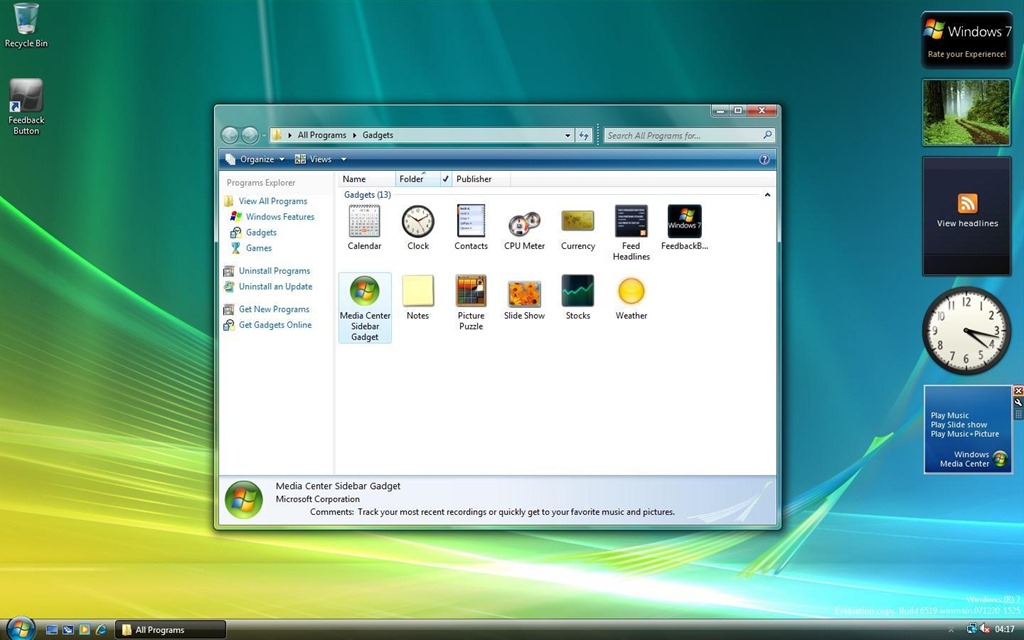
After parading the Sidebar and its gadgets as a new dawn for Windows, the whole thing was killed off after security vulnerabilities rendered it risky.

Widgets in Windows

Windows 11 introduced “Widgets(press WindowsKey+W to get them, or wave your mouse on the lower left of the screen) and later bulked up the UI with the same stuff you get on Microsoft Start, the Edge home page feed and so on, which probably means few people will use Widgets unless they want to find out about that heater that energy companies don’t want you to find out about, or that one thing (do it) that all Android users should know.

Great news, readers! The ability to switch off the “News” section is coming; at the moment, it’s dribbling out to some users on the Windows Insider program but at some point will be more widely available – read all about it here.

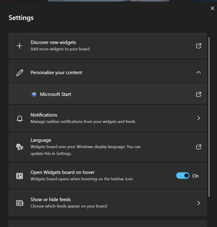
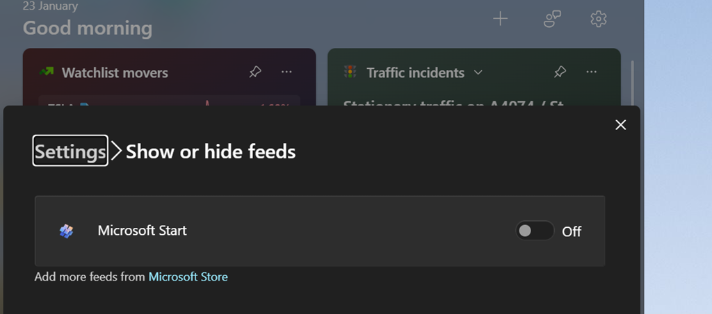
If you get the option (you should see a settings icon at the top of the Widgets board, rather than having to click on your profile photo to get to Settings), you can go into the Show or hide feeds option and be able to switch off the Start feed.

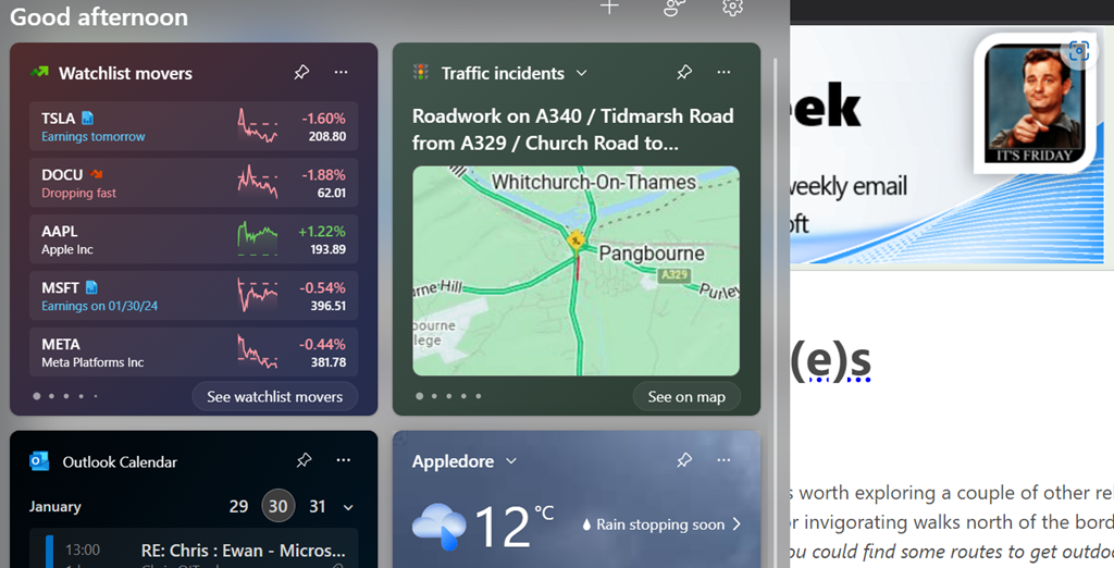
As well as being able to control the entire “feed” of content and present the gadgets on a 2-wide grid instead of a single column to the side, this update lets you choose which account to use to sign in to the Widgety experience, thus allowing users to sign in with their M365 account and use the widgets to surface stull like To-Do lists of tasks, or Outlook Calendar, showing data from their work or school account rather than only the Microsoft Account that it was previously locked to.

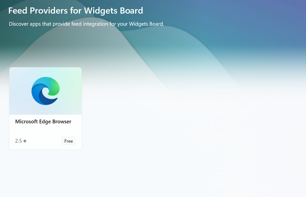
At some point, it looks like the Widgets feeds will be supplemented by other sources besides the Microsoft Start one (via the Add more feeds from Microsoft Store link in the show/hide feeds settings), with enthusiastic content providers lining up to publish their high-quality materials for all to consume…

But not today.


#10: More Mapping Bing(e)s

Following on from last week’s tip on Ordnance Survey mapping, it’s worth exploring a couple of other related topics. Reader Steven Grier recommends Walkhighlands: Scotland walks for invigorating walks north of the border (and not just the Highlands … it also covers Stevie’s native Burns country, so you could find some routes to get outdoors while practicing the forthcoming address).

Another regular, Mike Garrish, suggested looking at SysMaps, which aggregates a variety of different mapping services including Bing Maps. The UI takes a bit of getting used to but it does an effective job and makes up for Bing’s inexplicable removal of being able to export routes to .GPX files, by supporting that feature too.

Bing Maps can trace its lineage back nearly twenty years. Launched back in the days when Microsoft felt it needed to do everything its competitors were doing, even if not quite as well, the service was originally called Microsoft Virtual Earth (or Virtual North America, as one former colleague called it, given that everywhere outside of NA was still TBC; a bit like any sports tournament that has “World Series” in front of it). The Virtual Earth platform was aimed at developers looking to harness mapping in their sites and, later, apps. It offered up sometimes very good quality licensed mapping data and images for free, as part of the “Live” branding and then eventually morphed into being part of Bing. The Bing Maps Enterprise and Azure Maps services now form part of Microsoft’s “Map Platform”.

Start me up

The consumer-facing mapping service clings on despite having no discrete mobile client (in a browser, just go bingmaps.com to jump to it, or the alternative googlemaps.com, should you prefer being asked every five minutes if you’re rather use Chrome). There are mapping components in the expanding Microsoft Start mobile app, which is subsuming various formerly-separate apps like News and Money into a single application. Many of these things were at one point “MSN something”, might later have been lumped under Bing, but are now presented within Start like widgets, unsurprisingly slinging some ubiquitous Copilot in as well.

There’s a Copilot key coming to your next PC, the first major change since the Windows Key arrived with Windows 95, designed to make it easy to bring up the new Start menu. Remember that ‘Stones song? Here’s what it could have been like


“News” gives you much the same feed as the default New Tab Page on the Edge browser (ie. news from customizable sources, peppered with ridiculous clickbait and stupid adverts… albeit seemingly less so in this instance). From a mapping perspective, there’s a “Nearby” tile which tells you what attractions are close to you, and a “Commute” function which will warn you on the phone when there is trouble on the road ahead.

image

The PC app, Maps, is having its wings clipped somewhat, no longer able to work using offline copies of maps. Place your bets on how much life there is in the Maps app, given that it’s likely no longer going to be installed by default.

While it is still available, there are some pretty neat things in that app, like adding Ink annotations to maps which are saved on your PC (though not synced across machines) and using a pen to measure distance on-screen. Notably cool and unique to the Maps app (as compared to Bing Maps in a browser) is the 3D Cities feature. This lists quite a number of major and minor cities in the US, though its international coverage is a bit patchy – the only UK city on offer is Southampton, and while Australia has a few, you’ll not be looking out over the Harbour Bridge.

Back to the Streets

The Maps app offers no Ordnance Survey support for UK users but otherwise it basically does what Bing does in your browser.

It is worth noting, though, that the “not nearly as good as Google Street View” service called Streetside has been expanding internationally where it was a bit of a desert when launched first in the US (see earlier “World Series” comment) – in partnership with Tom Tom, Streetside has been adding more coverage though sometimes there’s not much they can do about being unable to go places.

It’s worth checking out Streetside either in the Windows Maps app or just in Bing Maps on a browser; you’ll definitely get a different view from the one you’ll see in Google.

#9: Go for a walk

Hello, ToW readers! It’s been a few couple of months now since the recent yet erstwhile host of “Tip of the Week” was acquired and their new owner has thus far not completed the repurposing of their content, and therefore not given me confidence in writing any more for them, for now. In the meantime, I’ll continue to dribble this stuff onto LinkedIn each Friday (as Tip o’ the Week always was, in the days when it was a Microsoft internal email), following from the restarted numbering system as at the time it changed from Tip o’ to Tip of.

I do hope you enjoy. Yay.

Now that we’re finally in the grip of the New Year, some NY resolutions might have been sacrificed already; eating less, moving more, not drinking too much and the like. If you’re still keen, maybe each weekend, why not get out into the great beyond and go for a walk?

Step 1 will be to decide where you’re going to walk to. Technology provides lots of help in that regard – from local website guides offering “10 great winter walks to take in your area” type articles (typically stuffed with clickbait and stupid advertising, though), to mobile apps and web sites like MapMyWalk, AllTrails and Visorando. Community enthusiasts might post their favourite routes on these and other fora, possibly with reviews to tell you how muddy they are / how many angry bulls you might encounter etc.

Screenshot 2024-01-12 134756
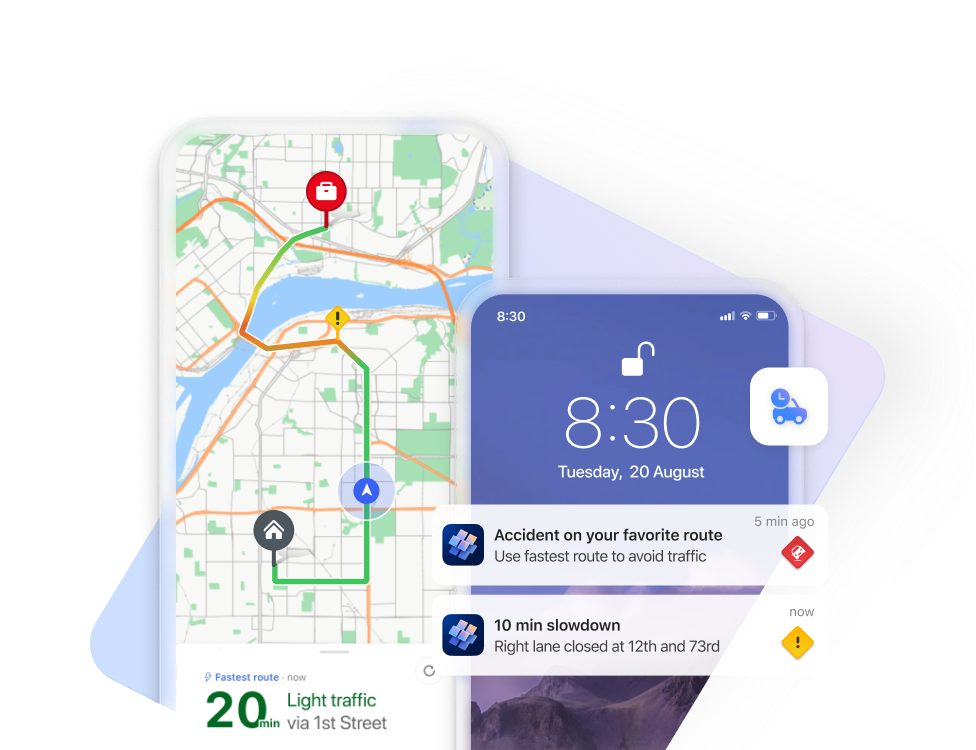
If you like the good old method of staring at a map and making up your own way, there are all the usual mapping tools available too. Google Maps clearly has a market share leadership position, and offers handy offline capabilities and walking directions, which sometimes include off-road footpaths as well. Not bad if you’re mostly in a built-up area, but once you’re in the sticks, you might be better off with more tailored alternatives. If you’re walking in London, check out Footways – a site showing a curated set of suggested “quiet” routes from A to B.

Apple pushes their alternative mapping software for Fruity device users, however if you follow a link to an Apple Maps location – eg https://maps.apple.com/?q=47.641944,-122.127222&t=k – and you’re not on an Apple device, it will send you to Google Maps instead. DuckDuckGo lets you view the map using another browser – eg https://duckduckgo.com/?q=47.641944%2C-122.127222&iaxm=maps – in case you feel like you’re missing out. [You’re not, btw]

If you’re planning a walk in the UK countryside, you’d do well to look at Ordnance Survey, a government funded department which publishes maps at varying scale and with key attributes highlighted. The organization dates back to the 18th century, set up to accurately map England in order to counter military incursions from troublesome neighbours. They still produce not-insignificantly-priced paper maps, however pinch-to-zoom is somewhat problematic on such offline media, so a mobile subscription based app with route planning, offline guidance and the like might be more fitting (and they have a 30% offer on annual subscriptions right now).

If you’re not inclined to subscribe, there is one alternative that’s useful when planning walks, even if you need to print the map out (or screen grab it to save the image to your phone): use Bing Maps.

Screenshot 2024-01-12 144611It’s easy to forget about Bing Maps (jump to bingmaps.com in a browser to get there quickly) since there’s no workable mobile solution, so most people will rely on the other main platforms. If you’re in the UK, however (and you set United Kingdom as your region in the hamburger menu on the top right) then you’ll be able to access Ordnance Survey mapping for free.

Look at the “Style” icon near the top right and you can choose road maps, satellite view and more, including Ordnance Survey. If you don’t see that option, you will need to play some more with your location settings. Zoom in or out until you get the right level, and you’ll see Explorer (slightly more detailed) and Landranger map views, showing key attractions with public footpaths marked.

Screenshot 2024-01-12 144928

Screenshot 2024-01-12 150614It’s brilliant. Right-click the map to use the measuring tool to draw your walk and calculate the distance. Screen-grab (WindowsKey+S) the section you want, and you could highlight your route from within the Snipping Tool before printing it out, nice and big and easy to read.